
Community
- Newsletters
- Nor-Gwyn Pool
- North Wales Library
- Right-to-Know
- Stormwater Management
- Trash & Recycling
- Volunteer Medical Services Corps of Lansdale
- Voter Information
- What is a Snow Emergency?
Liberty Bell Trail – Planning and Feasibility Study
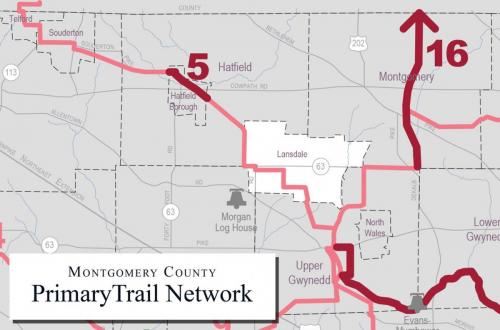
Introduction to Current Study: Eight municipalities in Montgomery County are collaborating with the PA Environmental Council and consulting firm, Michael Baker International, to advance the planning of the Liberty Bell Trail (LBT). Those municipalities include Upper Gwynedd Township, North Wales Borough, Lansdale Borough, Hatfield Township, Hatfield Borough, Franconia Township, Souderton Borough and Telford Borough. A prior LBT Feasibility Study completed in 2005 investigated the potential development of the former 25-mile Liberty Bell Trolley route between Norristown to Quakertown into a shared use path network for walking and bicycling.
This feasibility study will provide an update to the 11-mile portion of the LBT in Montgomery County. In the last 16 years, some progress has been made towards its completion including construction of approximately 1.5 miles in Lansdale Borough and another 0.5 mile in Hatfield Borough. As part of this trail update, we will investigate changes that have occurred along the planned trail route, explore alternatives, and make recommendations for a preferred trail route. These technical tasks will be supported by a robust public outreach program using numerous virtual and traditional outreach techniques. The study is anticipated to be completed by early 2022.
How can YOU get involved in the Montgomery County Liberty Bell Trail feasibility study? First off, make sure you participate in the WikiMap and fill out the associated survey. You can also reach out to your elected officials to express your support for the Liberty Bell Trail. If you would like to stay up to date on upcoming public meetings and events, be sure to check out our webpage. Email Zhenya Nalywayko (Znalywayko@pecpa.org) if you would like to be placed on our mailing list. Thank you for your support!
Links:
- WikiMap & Survey: https://wikimapping.com/Liberty-Bell-Trail.html
- Pennsylvania Environmental Council LBT Webpage: https://pecpa.org/program/liberty-bell-trail/
- Zhenya “Z” Nalywayko email address: Znalywayko@pecpa.org
See Full Article on the Liberty Bell Trail here: Liberty Bell Trail – Planning and Feasibility Study